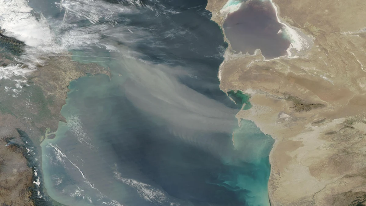
NASA's September 26 image of the day shows a broad gray plume crossing the Caspian Sea. The picture was acquired two days earlier by the MODIS instrument aboard the Aqua satellite. It is a useful example of what a photograph from orbit can establish at a glance, and where a single frame stops short of explaining an event.
Read the plume before the headline
The dust begins over the eastern shore and stretches westward across dark water. Its pale color and diffuse edge make it visible against the sea, while bright white clouds occupy the upper left. Those features can be separated visually, but the image alone does not identify every source of airborne material or measure the dust concentration. NASA's caption supplies the instrument, acquisition date, and weather context needed to read the frame responsibly.
According to the NASA MODIS gallery record , severe weather drove dust across the sea on September 24. The agency cites a warning from Kazakhstan's national weather service that forecast strong winds and dust storms. That is context from NASA's reporting, not a measurement contained in the pixels. The distinction is especially important when an image is shared without its original caption.
The gallery also describes a deadly incident involving naval personnel during the same adverse weather. It says an investigation into the contributing factors is underway. The satellite view documents the regional dust plume, but it cannot show what happened aboard a vessel, assign causation to a particular gust, or resolve the investigation. A striking image can establish scale without becoming proof of every human consequence associated with a storm.
Why this looks like a color photograph
NASA labels the frame a true-color image and lists bands 1, 4, and 3. The MODIS instrument specifications place those bands in red, green, and blue parts of the visible spectrum. Their data are combined to make a view that resembles visible-light color. That makes the dust and shoreline legible to a general reader, while preserving the fact that the result is a calibrated satellite product rather than an ordinary single-shot camera file.
MODIS is a scanning radiometer, not a handheld camera. NASA's instrument design account describes 36 spectral bands, a wide cross-track scan, and repeated global coverage. The gallery provides downloadable versions labeled 1 kilometer, 500 meters, and 250 meters. Those labels describe the scale of the underlying observations or delivered product, not a promise that every small shape in this compressed web image can be identified with that precision. The bands used here also have different native spatial resolutions.
For readers new to remote sensing, the MODIS overview provides the broader history of the instrument aboard Aqua and Terra. The crucial editorial question is narrower: which bands made this particular picture, when were its data acquired, and what can its resolution show? A gallery image can answer the first two through its metadata. The third depends on how the image is displayed and what claim is attached to it. A regional dust plume is a suitable subject. An individual vessel is not.
That technical detail changes how the picture should be viewed. At the scale of the whole Caspian Sea, it is good evidence that a plume spread far beyond a single shoreline. At the scale of a boat or a person, it is not evidence at all. Enlarging the JPEG makes the pixels larger, not the original observation more detailed. A photographer or editor who understands that boundary can choose a crop that communicates the event without implying an impossible close-up.
The date of capture matters
The gallery page is dated September 26, but the image facts say Aqua acquired the data on September 24. That two-day distinction belongs in every reuse of the picture. If a social card labels it only as a September 26 storm image, readers could mistake the publication date for the moment of observation.
A satellite frame also freezes one pass through a moving atmosphere. It does not track the plume's complete path or duration. A time sequence, measurements from the ground, and weather records would be needed to test how the dust evolved and what exposures followed. The value of this image is its regional view: the dark sea supplies contrast, the shoreline anchors direction, and the pale plume makes a large atmospheric movement visible.
This is a different image-making problem from the close timing discussed in our guide to photographing a Venus lunar occultation. That article follows a brief celestial alignment from the ground. MODIS trades fine subject detail for breadth and regular coverage. Both cases depend on recording when and how the frame was made before interpreting what it shows.
The most useful way to share NASA's Caspian image is to keep its credit and original source page beside it, state the September 24 acquisition date, and describe the plume at the scale the instrument actually supports. The image is compelling because it makes the weather visible. Its limits make the accompanying caption essential.
NASA credits the MODIS Land Rapid Response Team at Goddard Space Flight Center for the picture. Its media-use guidance permits factual editorial use of NASA material with acknowledgement and without implying agency endorsement. That credit is part of the image's evidence trail, not an optional decoration. It tells readers where to find the original data context when the photograph travels beyond NASA's own gallery.